Back كفالسوند Arabic Kvalsund BAR কভালসুন্ড BPY Kvalsund Catalan Kvalsund (munisipyo sa Noruwega) CEB Kvalsund Danish Kvalsund German Kvalsund Esperanto Kvalsund Spanish Kvalsundi vald Estonian
Kvalsund Municipality
Kvalsund kommune | |
|---|---|
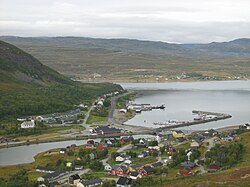
 View of Ráhkkerávju | |
 Finnmark within Norway | |
 Kvalsund within Finnmark | |
| Coordinates: 70°29′56.3″N 23°58′26.2″E / 70.498972°N 23.973944°E | |
| Country | Norway |
| County | Finnmark |
| District | Vest-Finnmark |
| Established | 1 July 1869 |
| • Preceded by | Hammerfest landdistrikt |
| Disestablished | 1 Jan 2020 |
| • Succeeded by | Hammerfest Municipality |
| Administrative centre | Kvalsund |
| Government | |
| • Mayor (2015-2019) | Terje Wikstrøm (Ap) |
| Area (upon dissolution) | |
| • Total | 1,844.29 km2 (712.08 sq mi) |
| • Land | 1,739.35 km2 (671.57 sq mi) |
| • Water | 104.94 km2 (40.52 sq mi) 5.7% |
| • Rank | #37 in Norway |
| Highest elevation | 986 m (3,235 ft) |
| Population (2019) | |
| • Total | 988 |
| • Rank | #394 in Norway |
| • Density | 0.6/km2 (2/sq mi) |
| • Change (10 years) | |
| Demonym | Kvalsundværing[2] |
| Official language | |
| • Norwegian form | Bokmål |
| Time zone | UTC+01:00 (CET) |
| • Summer (DST) | UTC+02:00 (CEST) |
| ISO 3166 code | NO-2017[4] |
Kvalsund (Northern Sami: Fálesnuorri and Kven: Valasnuora) is a former municipality in Finnmark county in Norway. The area is now part of Hammerfest Municipality. The municipality existed from 1869 until its dissolution in 2020. The administrative centre of the municipality was the village of Kvalsund. Other villages in the municipality included Áisaroaivi, Kokelv, Oldernes, Oldervik, Revsneshamn, Skaidi.
At the time of its dissolution on 1 January 2020, the 1,844-square-kilometre (712 sq mi) municipality was the 37th largest by area out of the 422 municipalities in Norway. Kvalsund was also the 394th most populous municipality in Norway with a population of 988. The municipality's population density was 0.5 inhabitants per square kilometre (1.3/sq mi) and its population had decreased by 5.4% over the previous 10-year period.[5][6]
The Kvalsund Bridge (Kvalsundbrua) is a suspension bridge that crosses the Kvalsundet strait from the mainland to the island of Kvaløya.
In 2015, the media said that for four years an application has been filed for establishing Norway's largest copper mine, depending on a permit for creating a zone in Repparfjorden for depositing waste from the mine.[7]
- ^ "Høgaste fjelltopp i kvar kommune" (in Norwegian). Kartverket. 16 January 2024. Archived from the original on 12 March 2019.
- ^ "Navn på steder og personer: Innbyggjarnamn" (in Norwegian). Språkrådet.
- ^ "Forskrift om målvedtak i kommunar og fylkeskommunar" (in Norwegian). Lovdata.no.
- ^ Bolstad, Erik; Thorsnæs, Geir, eds. (26 January 2023). "Kommunenummer". Store norske leksikon (in Norwegian). Kunnskapsforlaget.
- ^ Statistisk sentralbyrå. "Table: 06913: Population 1 January and population changes during the calendar year (M)" (in Norwegian).
- ^ Statistisk sentralbyrå. "09280: Area of land and fresh water (km²) (M)" (in Norwegian).
- ^ Ytreberg, Rune (12 September 2015). "Dette er ikke en lek". Dagens Næringsliv. p. 16.

